Geophysics
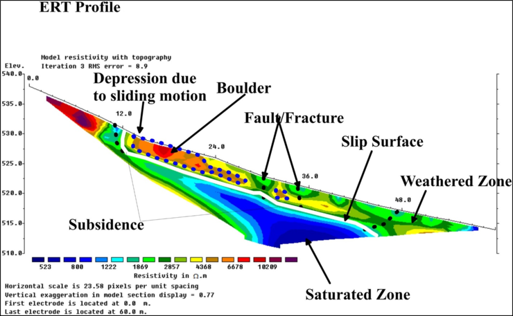
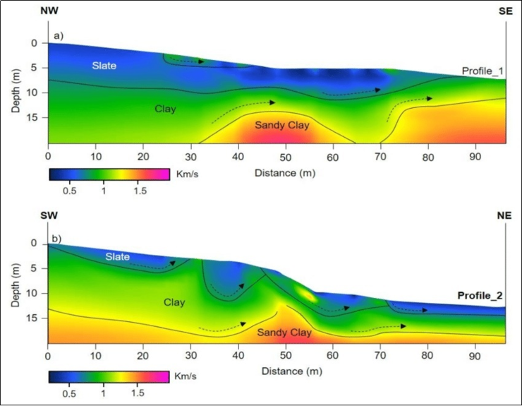
Geophysics uses non-invasive techniques like electrical resistivity and seismic surveys to map subsurface conditions. It helps identify weak zones, fractures, and groundwater pathways, providing critical insights for slope stability assessment and landslide risk mitigation At HIMGEO Consultancy Services Pvt. Ltd., we offer specialized Geophysical Investigation Services to support groundwater, environmental, mining, and geotechnical studies. Our expertise spans from survey design and field data acquisition to advanced processing, inversion, and interpretation for reliable subsurface characterization. We employ geophysical methods, including Electrical Resistivity Tomography (ERT), Seismic Resistivity Tomography (SRT) surveys, tailored to project-specific requirements. These non-invasive techniques help in delineating bedrock profiles, detecting weak zones. Our Geological and GIS-based integration with geophysical data ensures accurate delineation of subsurface structures and resources, enabling targeted and cost-effective solutions. By combining science, technology, and field expertise, we provide actionable insights to address challenges such as mass movement, slope instability, and infrastructure safety. 2D and 3D maps are prepared to understand subsurface features.
Electrical Resistivity Tomography (ERT) or Electrical Resistivity Imaging (ERI) is a modern geophysical technique used to create detailed images of the subsurface. By passing a small electrical current into the ground through electrodes and measuring the resulting voltage differences, ERT helps map variations in soil, rock, and groundwater conditions. It is a non-invasive, cost-effective method that is widely applied for groundwater exploration, spring-shed and watershed studies, contamination mapping, landslide investigations, and engineering site assessments. At HIMGEO Consultancy Services Pvt. Ltd., we use advanced ERT surveys combined with geological and GIS analysis to provide accurate and reliable subsurface information, enabling scientific planning and sustainable resource management.
Seismic Refraction Tomography (SRT) is a geophysical technique used to investigate subsurface geological conditions by analyzing the speed of seismic waves traveling through soil and rock layers. Variations in wave velocity help identify bedrock depth, weak zones, fractures, and groundwater pathways, which are critical for assessing slope stability and landslide susceptibility. At HIMGEO Consultancy Services Pvt. Ltd., we integrate Seismic Refraction Tomography with geological and GIS-based studies to provide precise subsurface mapping, enabling effective risk assessment and targeted mitigation strategies for safer slopes and infrastructure.